Map of the Ten Thousand Countries of the Earth October 20, 2012–January 21, 2013
Matteo Ricci, engraved by Li Zhizao, Map of the Ten Thousand Countries of the Earth (Kunyu wanguo quantu) (screen 5 of 6), 1601–02, woodblock print on rice paper, courtesy of the James Ford Bell Trust for the benefit of the James Ford Bell Library.
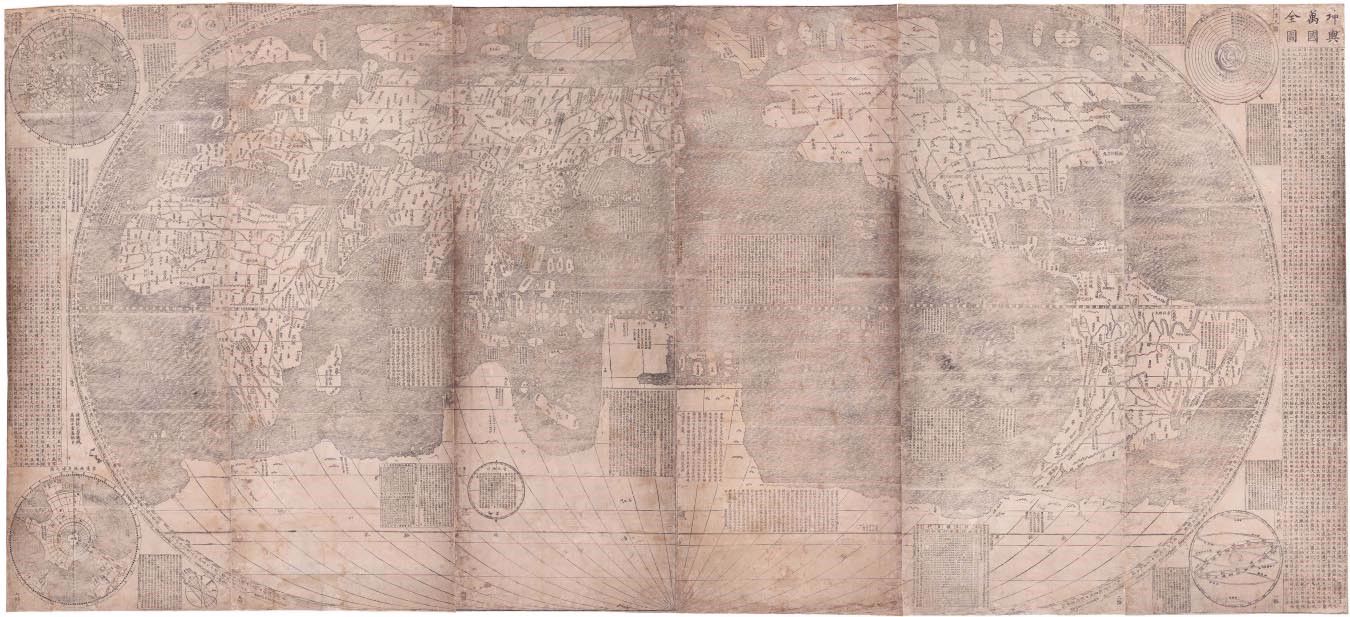
Matteo Ricci, engraved by Li Zhizao, Map of the Ten Thousand Countries of the Earth (Kunyu wanguo quantu), 1601–02, woodblock print on rice paper, courtesy of the James Ford Bell Trust for the Benefit of the James Ford Bell Library.
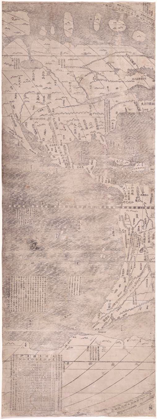
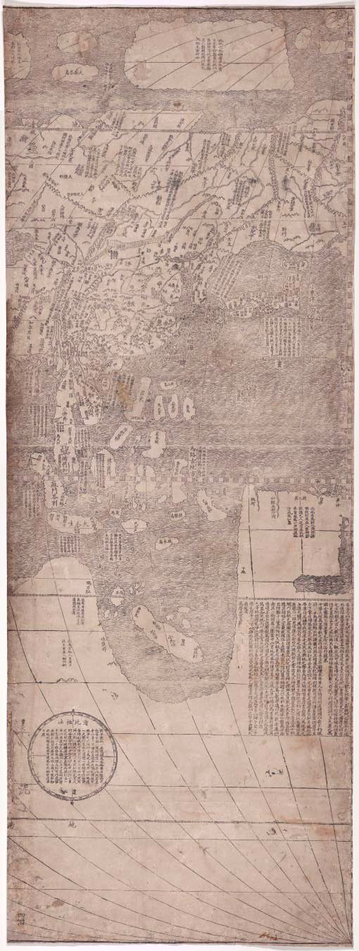
Matteo Ricci, engraved by Li Zhizao, Map of the Ten Thousand Countries of the Earth (Kunyu wanguo quantu) (screen 1 of 6), 1601–02, woodblock print on rice paper, courtesy of the James Ford Bell Trust for the for the benefit of the James Ford Bell Library.
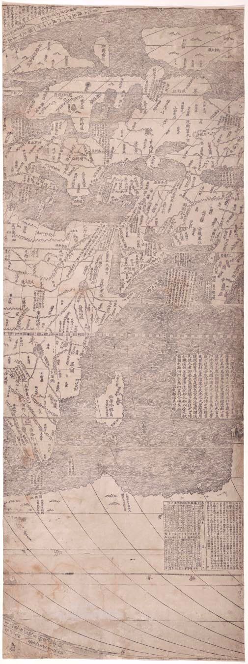
Matteo Ricci, engraved by Li Zhizao, Map of the Ten Thousand Countries of the Earth (Kunyu wanguo quantu) (screen 2 of 6), 1601–02, woodblock print on rice paper, courtesy of the James Ford Bell Trust for the benefit of the James Ford Bell Library.
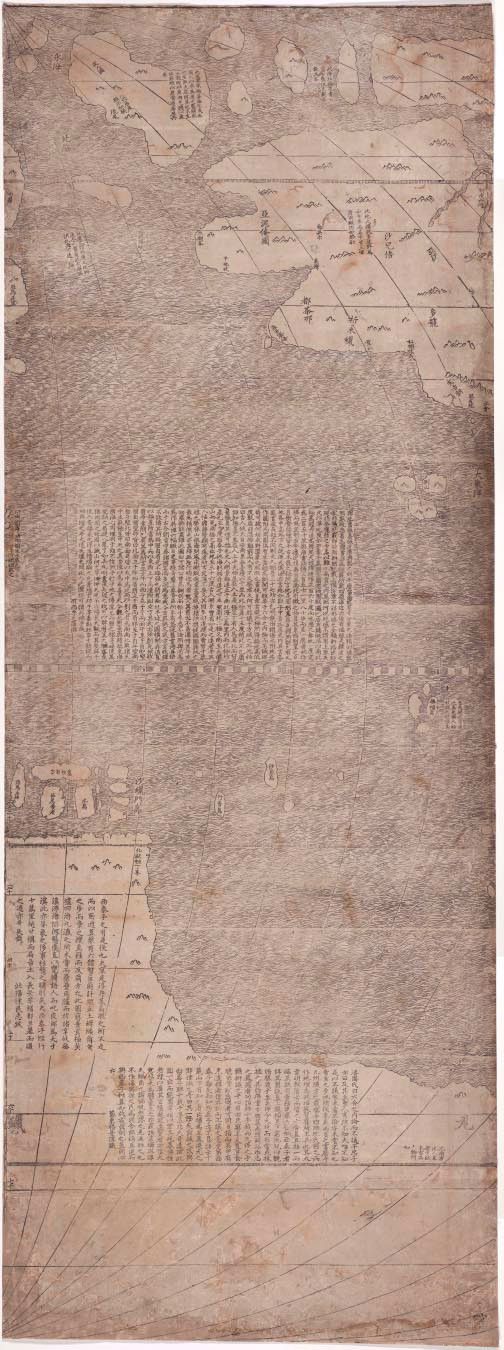
Matteo Ricci, engraved by Li Zhizao, Map of the Ten Thousand Countries of the Earth (Kunyu wanguo quantu) (screen 3 of 6), 1601–02, woodblock print on rice paper, courtesy of the James Ford Bell Trust for the benefit of the James Ford Bell Library.
Matteo Ricci, engraved by Li Zhizao, Map of the Ten Thousand Countries of the Earth (Kunyu wanguo quantu) (screen 4 of 6), 1601–02, woodblock print on rice paper, courtesy of the James Ford Bell Trust for the benefit of the James Ford Bell Library for the benefit of the James Ford Bell Library.
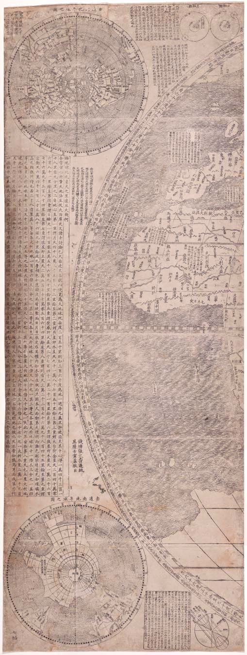
Matteo Ricci, engraved by Li Zhizao, Map of the Ten Thousand Countries of the Earth (Kunyu wanguo quantu) (screen 6 of 6), 1601–02, woodblock print on rice paper, courtesy of the James Ford Bell Trust for the benefit of the James Ford Bell Library.
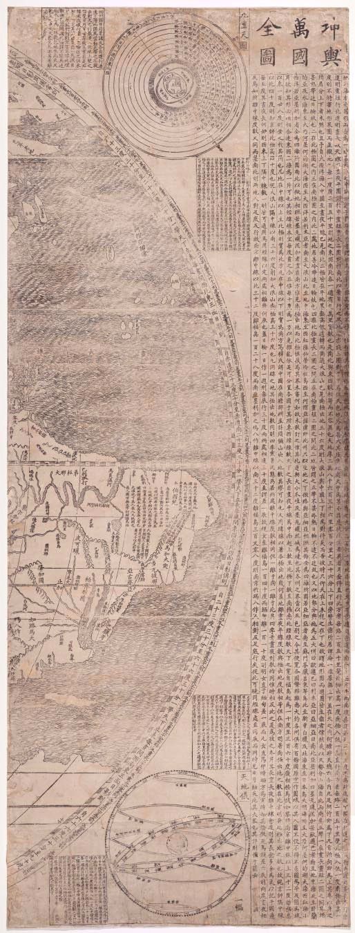
Matteo Ricci’s Map of the Ten Thousand Countries of the Earth (Kunyu wanguo quantu) is the oldest surviving map to provide the Chinese with a larger view of the earth. This extraordinary map, installed in the Ting Tsung and Wei Fong Chao Arts of China Gallery, is on loan to the MFAH from the James Ford Bell Trust for the benefit of the James Ford Bell Library.
Ricci (1552–1610), a Jesuit missionary who spent more than 30 years in China, studied science, mathematics, and geography. He learned Chinese, adopted the dress of a sage, and was the first European allowed into the Forbidden City. In 1602, he presented this map before the Ming Emperor Wanli. The map was engraved by Li Zhizhao (1565–1630), a Chinese mathematician, astronomer, and cartographer, and it was printed by Zhang Wentao of Hangzhou. Intended to be displayed over six two-fold screens, the map is approximately 12½ feet long and 5½ feet high. It was carved into six wood blocks that were printed on rice paper.
Ricci’s map pays tribute to the greatness of the Ming court, while simultaneously asserting Ricci’s own culture and religion. The map is covered with lively accounts of the world’s diverse peoples, as they were thought of at that time, and its legend presents detailed descriptions that refer to cosmography and astronomy. The map also includes a table showing the distance between the planets and the earth, and explanations of varying lengths of days and nights. Ricci drew from the maps of Abraham Ortelius (1527–1598), the creator of the first modern atlas, and Ming Dynasty Chinese maps and land surveys. Though China is shown at the center of the map, Ricci’s effort revolutionized the Chinese worldview.
This exhibition is made possible by the James Ford Bell Trust for the Benefit of the James Ford Bell Library.